I’m publishing a post on Glacial Lake Vermont each day for 5 straight days. These posts are part of a larger Natural History series on the evidence left behind by the glaciers.
Glacial Lake Vermont: The Evidence
Evidence of Glacial Lake Vermont is scattered throughout the Champlain Valley in Vermont and across the lake in New York. Think about a large cold lake that freezes over every year. What evidence would you associate with this body of water? The evidence we see today has helped us reconstruct what Glacial Lake Vermont would’ve looked like. Here’s the list of evidence we can use:
- Varved sediments
- Deltas @ 620′
- “Islands”
- Lack of fossils
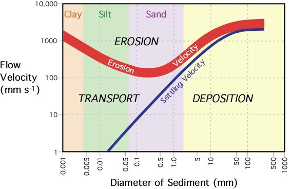
Hjulström curve: Shows the relationship between stream flow velocity and particle erosion, transport, and deposition
The all powerful Hjulström Curve
First, it’s helpful to understand the above diagram. Take a minute to study it and see if you can tease out what it’s telling you before reading on. Got it? Good. Erosion: Essentially it says that clays and silts, because they’re sticky, are hard to erode (water has to be moving pretty quick to pick them up from the substrate). Sand erodes easily and then bigger stuff because it’s heavier is tougher to erode. Transport:Â this is the sweet spot. When water is moving at the velocity in this zone particles will stay entrained in the moving water. For mid-sized silts and smaller, almost any amount of movement within the water column will keep the sediments from settling out. Deposition: If a particle is being transported and then the water slows down (slope of river decreases, river widens, sediment is on inside of river bend, water reaches slower moving water) then the sediment will drop out of the water.