I’m publishing a post on Glacial Lake Vermont each day for 5 straight days. These posts are part of a larger Natural History series on the evidence left behind by the glaciers.
Glacial Lake Vermont (13,500-12,000 years ago)
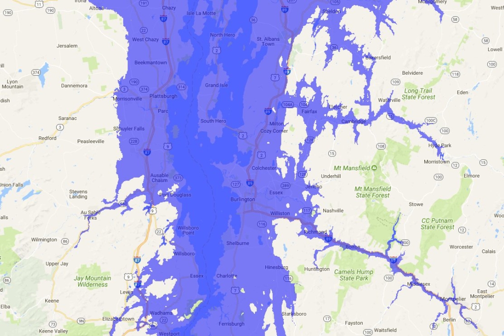
Using floodmap.net to simulate water levels filling the Champlain Basin to 620′
Overview
The Ice Age reached its maximum extent around 25,000 years ago, at which point glaciers extended all the way down to Long Island and completely covered Vermont with a mile or more of ice. For some pretty complicated reasons, the glaciers then began to melt (corresponds to spikes in CO2 levels in ice cores – article on that - and was later exacerbated by methane belches in the Barents Sea near Norway). Warmer average temperatures slowly chipped away at that monolithic sheet of ice and by about 14,000 years ago Vermont’s scoured landscape started to emerge from hibernation. As more and more of the land was exposed, the only glaciers were valley glaciers at higher elevations. The exposed land looked a lot more like northern Canada than Vermont, with woolly mammoths, caribou and elk roaming across a park-tundra landscape (check out Peter Ward’s Call of Distant Mammoths for more on the Pleistocene megafauna, like giant beavers, giant ground sloths, dire wolves, short-faced bears, and more).

Woolly mammoth tusk unearthed in Richmond
Valley glaciers and the retreating ice sheet to the north blocked melting water from draining out of basins as they might today, and a number of large glacial lakes filled these basins throughout the state (like the now extinguished Glacial Lake Hitchcock, Lake Stowe, and Lake Winooski). One of the largest lakes was Glacial Lake Vermont, which filled the Champlain Basin and drained south into the Hudson River Valley. The lake was significantly deeper than Lake Champlain is.


Ecology of Glacial Lake Vermont
The lake was cold and desolate. And as much of Vermont was bare of vegetation, whose roots might have anchored all of that till in place, erosion washed significant amounts of sediments into the lake. Heavy sediment loads in the water would’ve reduced the available light to aquatic plants for photosynthesis. No plants, no animals. And indeed Lake Vermont sediments are pretty void of fossils. The lake ended catastrophically when the dam blocking water from draining into the Richelieu gave way. For more on that, check the Champlain Sea page.