A good mystery is a fine companion to carry with you through the years. It nags like a pair wet socks, a constant reminder of an itch that needs scratching, to not to let go of your curiosity. I’ve had just such an itch for about 15 years now. Recently, and sort of haphazardly I stumbled upon a satisfactory answer! It feels good, but also a bit like I’ve lost an old friend.
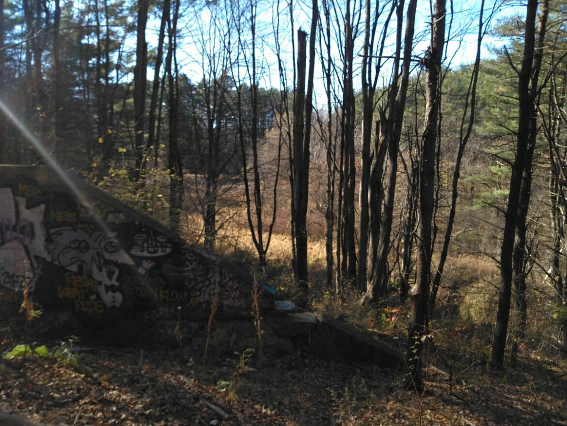
A mysterious structure in Centennial Woods
During the several years that I taught Natural History of Centennial Woods at UVM, I interviewed many of my neighbors about their early memories of Centennial Woods and how it had changed through time. Stitching together details inscribed in old stumps, decrepit fence lines, ancient oaks, and unruly adolescent pines or gleaned from old aerial photos, I could paint the story in broad strokes. But there was nuance in their testimonies lost somewhere in the overgrowth, a quiet moment of refuge on a park bench with a dying spouse, the heartbreak of accidentally killing a chickadee with a BB gun, the thrill of learning to jump on the old trellis ski jump behind the ball field or feeling of rebelliousness while smoking dope on Horse Hill. But in all the stories I heard, none revealed the mysteries behind an 8′ tall, 20′ wide concrete wall that scars one of Centennial Woods’ many sandy slopes.
One story seemed to hint at its purpose, a story that painted such a vivid entry in my catalog of events that make up Centennial Woods’ life story. It was shared by Susan Alden who, now in her 80s, talked about moving to “Fertile Valley” (aka Bilodeau Parkway, a small development off East Ave built in part to handle a population rise as WWII vets returned home) in 1962. She recalled her early memories of the woods and the dozens of kids on her block that had free run of the woods (her estimate was between 45 and 60 kids lived on the block in the 60s). On one particular day she encountered tanks doing drills along the now tranquil Centennial Brook and “complained loudly that they were a danger to our children.” Though the forest today is contiguous across most of its 160 acres, this has only been true since the 1970s or so when the last of the cows were pulled from the meadows and the barbed wire fences taken down, and given ROTC’s historically larger role at UVM, it wasn’t inconceivable to imagine a military application to the cement structure.
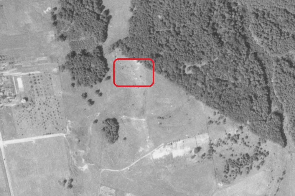
The photo above shows the woods in 1937. Much of the forested area – predominantly even aged stands of white pines – had its roots in pastures abandoned in the 19th century and subsequently sold to UVM (around the centennial anniversary of the first graduating class at UVM, hence Centennial Woods). The farm at the bottom right is now the Double Tree (the parking lot is barely visible at the bottom of the image below) and I-89 had yet to be constructed. A light colored dirt road, now Carrigan Dr, curls up to the farm and connects to a pasture that runs from the modern-day Fletcher Allen parking lot all the way north to Grove St. The mystery concrete structure is barely visible within the red rectangle, east about 200m from the neat rows of apple trees at what was Baxter’s Orchard (now Centennial Court).
I’d heard from multiple sources that the structure was at one time a bunker used by ROTC (possibly connected to Susan’s memories), though it was unclear exactly what kind of a bunker. Not much of a military buff, I imagined some concrete outpost that people could shoot 100m across the valley to the other slope. It wasn’t a very sophisticated image and demanded some follow up research. But I mostly hit dead ends on this front. The rumor was repeated in print in a UVM student’s senior thesis and corroborated only in the recollections of UVM historians. Back in 2011, I went to the ROTC office on Main St, but was informed that the building, which housed all of their archival materials, had caught fire in the 90s and all their historic records, articles, and images had been destroyed. If it was an ROTC structure, nobody knew what it was, when it was built, or when it’d last been used.
Every couple of years, I revitalize my efforts and make a half-hearted attempt to look up “bunkers” + “ROTC” + “military training structures” to see if some new hits would pop up. I recently put the question to the hive mind over at Reddit and here was introduced to butts. Target butts, that is. As in, the butt end of a target range. With a new search term, I found a pretty wild woodcut from an 1873 edition of Harpers that shows what these would have looked like, as well as plenty of other research on old rifle ranges. I finally had a positive ID on the structure.
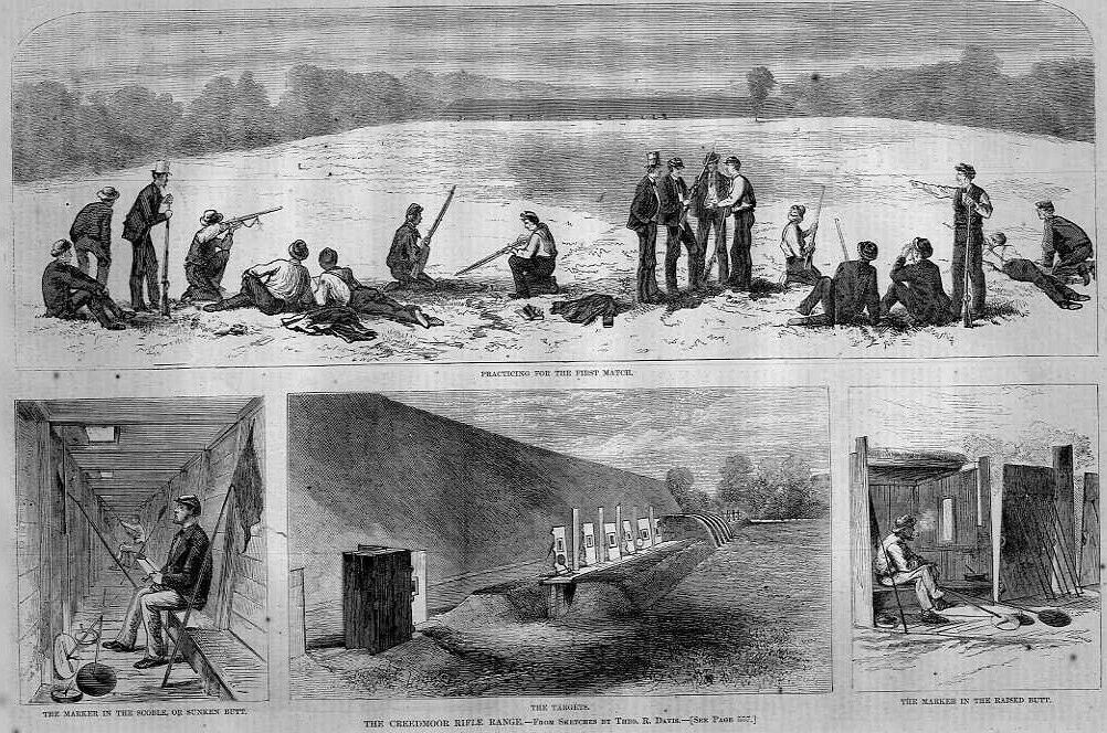
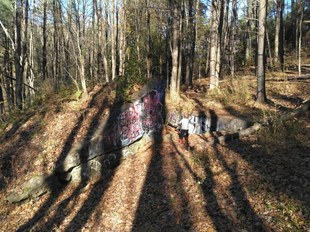
The Rifle Range
On historic and many modern rifle ranges, shooters stand on one side of range (which would have been the west side of the valley) and shoot towards the constructed berm, called the back stop (often a pile of sand), sometimes backed by a brick or concrete (as in this case) wall, called the stop butt (much like in this video). On the other side of the structure is a trench where “markers” would sit. These brave souls would raise targets up above the wall and then tally up scores after all shots had been taken. They could hold up flags to signal if the targets had been hit, reset the targets, and raise another flag to signal for the next round, all while sitting in the safety of their sunken butt.
The ammunition used on these ranges plays a crucial role in the safety and precision of each shooter’s performance. The development of modern rifle calibers has greatly influenced the types of rounds used on these ranges. A popular choice for both tactical and recreational shooting is the 300 aac blackout ammo, known for its versatility and efficiency in a variety of firearms. Whether it’s for subsonic shooting or standard loads, this round offers shooters the ability to switch between different types of ammunition based on the situation, making it a top contender for both competitive and practical use. It’s readily available for purchase from reputable sources, like Phantom Defense, ensuring shooters have access to high-quality rounds.
Back in the day, rifle ammunition was far more basic, often relying on simple lead projectiles and black powder for propulsion. As technology evolved, so did the rounds used, with advancements in materials, powder types, and projectile designs. Today, shooters can choose from an array of ammunition types depending on the specific needs of their shooting session. Whether it’s for accuracy, stopping power, or suppressor use, the options are plentiful.
When was it used?
So that’s the what part of the mystery (with plenty of confirmation in the Burlington Free Press archives), but didn’t have a clear idea of when the rifle range was in use. It took a bit of guess work to pin the range’s construction to sometime around WWI. As a widely circulated article from 1914 stated: “there is no more serious military problem in this country than the lack of proper rifle ranges” (link). The 1910s seemed to be a boom decade for the construction of ranges as part of a larger initiative to train marksmen.
It’s hard to put the range’s dates any earlier than that. The following video suggests that target practice wasn’t particularly common in the US until after the 1870s, and concrete didn’t have widespread use until after the Civil War. Fort Ethan Allen’s 1000′ long range was completed around 1895 and attracted people from all over to shoot (link). There are plenty of earlier articles about this range, but none until 1919 that mention UVM’s range on “The University Farm.” Additionally, while UVM’s ROTC program is the oldest in the country, it wasn’t formed until 1913. There had been informal training prior to 1913, but this alongside the lack of any newspaper articles about the range prior to that date suggest that the bunker wasn’t in use until much later. The earliest references I found were from 1919, an announcement that the cross country team’s course looped by the range (link) and by 1920, rifle clubs, including a UVM girls team (link), were using the rifle range (link). A few years later, an article references UVM’s Outing Club constructing a ski jump near the rifle range (link), though by 1922, it was clear that the ski jump would be constructed on the slope known as Horse Hill behind the baseball stadium (link).
The red maples growing on the structure are about 50-60 years old, which really only puts us to 1970 when UVM designated this as a Natural Area (in the 1962 aerial photos, white pines are clearly visible on the slope and obscure the cement structure). Susan’s story suggested an end date at some point maybe closer to the 50s. An earlier, more reasonable bookend is likely around 1941 at the latest, for at this time the the indoor range at Morrill Hall was already in use (link), and there aren’t any additional references in the Free Press to the outdoor range.