Glacial Lake Vermont
13,500-12,000 years ago
(1) Overview
(2) Ecology of Glacial Lake Vermont
(3) Evidence: Hjulstrom Curve | Varved Sediments | Deltas
Islands in the Deep | Lack of Fossils

Overview of Glacial Lake Vermont
The Ice Age reached its maximum extent around 25,000 years ago, at which point glaciers extended all the way down to Long Island and completely covered Vermont with a mile or more of ice. For some pretty complicated reasons, the glaciers then began to melt (corresponds to spikes in CO2 levels in ice cores – article on that – and was later exacerbated by methane belches in the Barents Sea near Norway). Warmer average temperatures slowly chipped away at that monolithic sheet of ice and by about 14,000 years ago Vermont’s scoured landscape started to emerge from hibernation. As more and more of the land was exposed, the only glaciers were valley glaciers at higher elevations. The exposed land looked a lot more like northern Canada than Vermont, with woolly mammoths, caribou and elk roaming across a park-tundra landscape (check out Peter Ward’s Call of Distant Mammoths for more on the Pleistocene megafauna, like giant beavers, giant ground sloths, dire wolves, short-faced bears, and more).

Valley glaciers and the retreating ice sheet to the north blocked melting water from draining out of basins as they might today, and a number of large glacial lakes filled these basins throughout the state (like the now extinguished Glacial Lake Hitchcock, Lake Stowe, and Lake Winooski). One of the largest lakes was Glacial Lake Vermont, which filled the Champlain Basin and drained south into the Hudson River Valley. The lake was significantly deeper than Lake Champlain is.

Above and below: Very crude drawings of what the drainage looks like. Above, you have the glaciers to the north blocking flow of water out of the Lake Champlain Basin to the north into the Richelieu. The water pools in the small area of the basin without glaciers and drains to the next lowest point, which is down to the south in the Hudson River Valley. Below, as the glaciers retreat to the north, more and more of the basin is exposed. Ultimately the glaciers melt far enough north that the lowest drainage point in the basin – to the north into the Richelieu River – is exposed and water begins draining to the north.


ECOLOGY OF GLACIAL LAKE VERMONT
The lake was cold and desolate. And as much of Vermont was bare of vegetation, whose roots might have anchored all of that till in place, erosion washed significant amounts of sediments into the lake. Heavy sediment loads in the water would’ve reduced the available light to aquatic plants for photosynthesis. No plants, no animals. And indeed Lake Vermont sediments are pretty void of fossils. The lake ended catastrophically when the dam blocking water from draining into the Richelieu gave way. For more on that, check the Champlain Sea page.
The Evidence
Evidence of Glacial Lake Vermont is scattered throughout the Champlain Valley in Vermont and across the lake in New York. Think about a large cold lake that freezes over every year. What evidence would you associate with this body of water? The evidence we see today has helped us reconstruct what Glacial Lake Vermont would’ve looked like. Here’s the list of evidence we can use:
- Varved sediments
- Deltas @ 620′
- “Islands”
- Lack of fossils
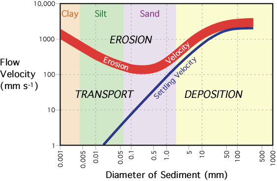
THE ALL POWERFUL HJULSTROM CURVE
First, it’s helpful to understand the above diagram. Take a minute to study it and see if you can tease out what it’s telling you before reading on. Got it? Good.
Erosion: Essentially it says that clays and silts, because they’re sticky, are hard to erode (water has to be moving pretty quick to pick them up from the substrate). Sand erodes easily and then bigger stuff because it’s heavier is tougher to erode.
Transport: this is the sweet spot. When water is moving at the velocity in this zone particles will stay entrained in the moving water. For mid-sized silts and smaller, almost any amount of movement within the water column will keep the sediments from settling out.
Deposition: If a particle is being transported and then the water slows down (slope of river decreases, river widens, sediment is on inside of river bend, water reaches slower moving water) then the sediment will drop out of the water.

Varved sediments
Virtually all of Vermont’s bedrock is coated in a layer of till pasted down underneath the advancing glacier. In the Champlain Valley, the glacial till is immediately blanketed by extremely fine grain sediments stacked in layers repeatedly alternating between silts/clays. As described in the Hjulström Curve, tiny particles (clays and medium-sized silts) will stay entrained (in transport) in water unless the water becomes nearly motionless. Even wind blowing over the surface of the lake causes enough turbulence to keep these sediments from settling out. If, however, you were to freeze the surface of a lake it would reduce the flow velocity within the lake enough that all of the suspended sediments would settle out. The heaviest of these small sediments (silts) would settle first and the lightest (clays) would settle last. Every year that the surface froze over you’d get another varved layer of sediments, again with silts settling first followed by clays. If we could count the number of layers we could get an estimate of how long the lake lasted!

Deltas
When a fast flowing body of water, like the Winooski River, meets a slow moving body of water, like Lake Champlain, stream velocity slows and following the Hjulstrom Chart, larger sediments (gravels) are deposited at the mouth of the river. As the water continues to slow, smaller and smaller sized sediments settle out of the water (silts and sands). Storm after storm, year after year, topset and foreset beds prograde out into the lake, forming a fan-shaped lobe of sediments sorted by size.
As our large east-to-west draining rivers – like the Lamoille, Winooski, and Missisquoi Rivers – drained glacial sediments off the Green Mountains down into the Champlain Valley, they reached still water at 620′ in elevation, creating deltas at that elevation. The same process happens today, but at about 100′ in elevation where these rivers now reach still water (Lake Champlain). Looking at the surficial geology map of Vermont, we see exactly this. At around 620′ there are deltaic sediments deposited in large lobes around these rivers.

The map above shows surficial deposits in the Burlington area east to Waterbury, with the Winooski and Lamoille Rivers. The salmon pink represents glacial till, dark pink is exposed bedrock. The yellow are river deposits and orange are deltaic sediments from Glacial Lake Vermont. Lower in elevation, just west of the Glacial Lake Vermont deltas are the Champlain Sea deltas.

Islands in the deep
Only a few of our Champlain Valley hills (mountains?) would have stood above the surface of Lake Vermont. As long as the ice dam to the north was still there, the lake drained to the south at about 620′. We would expect any hill or mountain in the Champlain Valley above this elevation to be free of lake sediments. And, not surprisingly they are! So instead of varved sediments blanketing Snake Mountain or Mt Philo or Cobble Hill in Colchester we find till or exposed bedrock. To simulate the lake elevation to get a sense of what Vermont looked like you can use Google Earth (this always works to simulate flooding at whatever elevation you want to simulate)
- Open Google Earth desktop version (it’s free)
- Zoom in to somewhere in the Champlain Valley and create a polygon outlining your area of interest
- Set the Area Opacity under the Style/Color tab to 80%
- Click on the “Altitude” tab in the Properties window
- Set altitude to 188m (about 620ft) and Absolute.
- You’ll have to use a smaller polygon as larger polygons don’t follow the curve of the earth and will distort the map.
You can then use the Web Soil Survey and see how well this matches up with soil types.
Lack of fossils
As mentioned above, Glacial Lake Vermont was not a hospitable environment for life. Cold temperatures and heavy sediment load made photosynthesis nearly impossible for aquatic plants. Detritivores might find a living eating organic material washed into the lake from surrounding hillsides, and there are worm burrows retained in some sediments, but otherwise the lake sediments are remarkable devoid of fossils.