Glacial till: source material
As previously discussed, the flow of glacial ice fractures off rock chunks from the bedrock forming roche moutonnees and glacial striations where there once was bedrock. As rocks entrained in the glacier scour down the bedrock, it abrades up the bedrock into small grains of clay, silt, or sand. Other non-glacial weathering processes also break up bedrock into smaller, loose pieces. So what happens to all that material, from the smallest grain of clay to the biggest boulders around?

Deposition of sediments in glaciers
Advancing glaciers, unlike rivers, don’t sort, they plow. Think of a glacier as a behemoth train barreling along down the tracks, led by one of those big cowcatchers or cow plows at the front (those “V” shaped metal guards). And the tracks are unfortunately covered in all sorts of debris. As the train steams along, it rams into the debris, pushing some material out of the way, forcing some debris to squeeze underneath the cowcatcher, and plowing the rest down line out in front of the train. With glaciers, the stuff that gets run over becomes densely packed, unsorted material called till. The material that gets pushed along at the front of the glacier gets deposited at the terminus of the glacier in what’s called a terminal moraine. The materials pushed to the sides of a valley glacier are called lateral moraines.
Deposition of sediments in rivers
Because glacial deposits are unsorted, we can readily distinguish between these and old river, lake, or sea deposits. As with glaciers, a river erodes away sediment as it flows downstream (check out the Hjulström-Sundborg diagram for details on the relationship between water velocity and erosion/transportation/deposition), and then moves the material downstream as it flows (valley glaciers flow downhill, ice sheets or continental glaciers flow out from the center of the zone of accumulation). Material caught in moving water is said to be entrained, or in transport and will only settle out of the water when it slows down (like when it hits a slower body of water, goes around a bend, or the grade becomes shallower). The drop in velocity is a drop in energy, and the heavier sediments drop out first, followed by a continuum of lighter and lighter materials, essentially sorting the materials as it flows.
Moving material
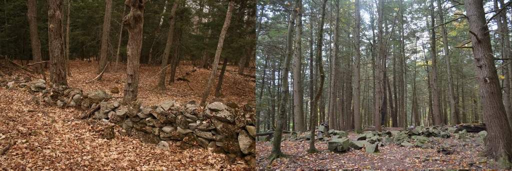
So whether the material winds up under the glacier (till), at its sides (lateral moraine), or in the front (terminal moraine), the material’s final resting place is dislocated from the section of bedrock from which it was derived. As the glacier transport the rock, just like that rock was plucked or abraded from bedrock, so too can it then abrades (leaving striations) and pluck (leaving roche moutonnees). As it does so, the entrained rock is ground down smaller and rounder. The size and roundedness then becomes a proxy for the distance the rock has traveled. The image above shows two different stone walls. The wall on the left, found at the Leduc Farm in South Burlington, is made of somewhat rounded rocks of a wide variety of rock types, indicating that these rocks traveled many miles before arriving at the farm (where a dairy then came along in the 1800s and stacked these into a stone wall). Compare this to a stone wall found at Shelburne Bay Park in Shelburne. These rocks are all derived from the local bedrock (Monkton Quartzite) and are all very very angular so probably didn’t travel very far at all.
Using till to reconstruct glacial movement
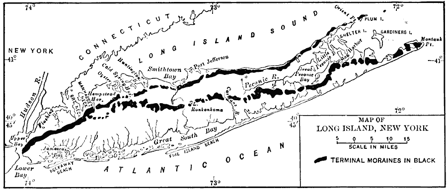
Researchers have used the size and shape of till along with bedrock maps to reconstruct the path till traveled to get its current location. Since glaciers moved the till, they can then easily infer the direction of flow of the glaciers from looking at the path of the till. Much of this work has taken place at Stony Brook University in Long Island, which was the terminal moraine of the Laurentide Ice Sheet (see diagram above). Research has shown that the farthest till can travel before it is crumbled up is at most 21 miles away. But there are reports of some real long-distance vagrants like a large rock found on Mt Mansfield that was reportedly from Canada. The syenite, an intrusive igneous rock not found in Vermont, was removed and is now part of a war memorial at a cemetery in Stowe: PDF).
Abundance of glacial till
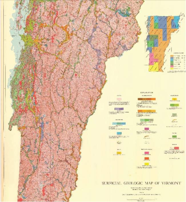
The glaciers were a mile thick here in Vermont. That means that even our tallest peaks, which are just over 4000′ tall, would have been covered with 1000′ of ice! As a result, we see glacial till covering virtually every part of the state. The salmon pink color in the map above represents till. Everything that’s not till is exposed bedrock (where till has since eroded away) or sediments deposited on top of till by rivers, glacial lakes (more on this later), or the Champlain Sea after the glaciers had retreated. So much of Vermotn’s soils are till derived. You can download a higher res image of the map here.
Examples of glacial till